
Verified geolocation data from late April 2026 suggests a marginal westward shift of the contact line as Ukrainian counter-offensives target Russian defensive nodes along the Voskresenka-Maliivka corridor.
April 28, 2026
Last Updated: April 28, 2026
By Global War News Editorial
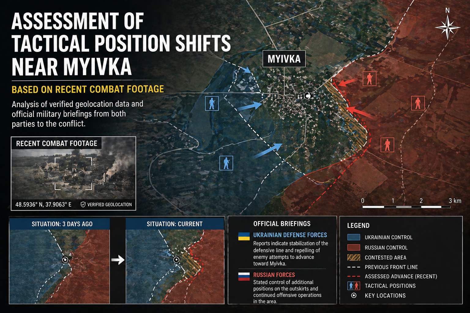
Recent combat footage and satellite analysis from the Oleksandrivka-Hulyaipole sector indicate a series of tactical penetrations near the settlement of Myivka (northeast of Oleksandrivka). Reports from military observers, including the Institute for the Study of War (ISW) and the Ukrainian OSINT group DeepState, suggest that Ukrainian assault groups have successfully established a presence on the eastern outskirts of the village, forcing Russian units to adjust their defensive posture.
This development follows a broader Ukrainian drive that has reportedly reclaimed over 400 square kilometers in the southern theater since late January 2026. The engagements near Myivka are characterized by small-unit actions and intensive drone surveillance, with both parties utilizing tactical UAVs to adjust artillery fire in real-time. While the Russian Ministry of Defense has reported “repelling attacks” in this direction, geolocated footage confirms a slight contraction of the Russian-controlled “gray zone” in the vicinity.
Geolocation Data and Battlefield Verification
Analysis of geolocated footage published between April 24 and April 27, 2026, provides physical evidence of the shifting frontlines. Footage showing Ukrainian FPV drone strikes on Russian armored vehicles within the village limits of Myivka confirms that Ukrainian forces have advanced beyond previous assessments.
- Verified Positions: Geolocation data confirms Ukrainian presence at $47.5833^{\circ} \text{N}, 36.4167^{\circ} \text{E}$, placing them approximately 800 meters west of their early-April positions.
- Russian Defensive Line: Russian forces, specifically elements of the 39th Motorized Rifle Brigade (68th Army Corps), have reportedly withdrawn from exposed forward positions to a more defensible line along the Voskresenka-Maliivka ridge.
- Combat Intensity: The Ukrainian General Staff reported 226 combat clashes across the entire theater in the 24 hours leading up to April 28, with the Myivka sector noted as a site of “localized positional battles.”
Official Briefings: Divergent Narratives
As with many localized frontline shifts, official accounts from Kyiv and Moscow present differing interpretations of the weekend’s engagements.
Ukrainian General Staff Perspective
According to the morning briefing from the Ukrainian General Staff on April 28, Ukrainian forces “improved their tactical position” in the Hulyaipole direction. The briefing emphasized the neutralization of a Russian electronic warfare (EW) station near Myivka, which had previously hampered Ukrainian drone operations. Ukrainian officials have framed the advance as part of a methodical effort to sever Russian logistics connecting the southern and eastern groupings of forces.
Russian Ministry of Defense Perspective
The Russian Ministry of Defense, in its daily update on April 27, stated that its “Vostok” Group of Forces had “defeated manpower and equipment” of the Ukrainian 108th Territorial Defense Brigade near Myivka and Hulyaipole. The Russian account stresses that Ukrainian attempts to breach the main line of defense were intercepted by artillery and aviation. While the MoD acknowledged the high intensity of the fighting, it did not explicitly confirm the loss of forward positions within the village.
Analysis: The Strategic Value of the Maliivka Corridor
Analysts suggest that Myivka itself is less a strategic objective and more a critical tactical node. Its location on the northern flank of the Russian push toward Orikhiv makes it a vital defensive anchor.
Observers note that by pressuring Myivka, Ukrainian forces are effectively threatening the rear of Russian elements attempting to advance west from Hulyaipole. This “flank pressure” has compelled the Russian Eastern Grouping of Forces to redeploy reserves—including elements of the 40th Naval Infantry Brigade—from other sectors to shore up the Myivka-Voskresenka line.
Furthermore, the recent spring-summer drying of roads in the region has enabled the use of motorized assault groups. However, the pervasive use of “human safari” drone tactics—where FPV drones are used to hunt individual soldiers and vehicles—has slowed the pace of territorial shifts on both sides.
Closing Summary
As of April 28, 2026, Myivka remains a contested “gray zone,” with Ukrainian forces holding the eastern outskirts and Russian forces maintaining control of the high ground to the northeast. While the territorial shift is measured in hundreds of meters rather than kilometers, the tactical success of the Ukrainian penetrations has forced a significant redeployment of Russian assets. We will continue to monitor geolocation updates for any signs of a deeper breach in the Voskresenka-Maliivka line.
Sources: This article utilizes geolocated footage verified by DeepState and ISW. Official briefings are sourced from the General Staff of the Armed Forces of Ukraine and the Ministry of Defense of the Russian Federation. Economic and casualty data refers to recent briefs from the UN and IISS.
This article is based on publicly available reporting from named international news agencies and attributed official statements. All claims about ongoing events are attributed to their original sources. Analysis sections represent the editorial interpretation of reported facts and do not constitute advocacy for any party to the described conflict. AI tools may be utilized for image generation to assist in explaining complex concepts, as well as for refining grammar, spelling, and other linguistic enhancements. However, all original content is produced, fact-checked, and revised by the editorial team. This publication does not take political positions on active military conflicts.